A new round of cold wave weather is coming, and a large range of rain and snow in the central and eastern regions reappear.
China Weather Network News Cold wave weather strikes again! Yesterday (December 12th) night, a new round of cold wave weather process was launched. This cold wave is coming. It is expected that it will bring rain, snow and cooling to most parts of China until the 17th, and the temperature will generally drop by 8~12℃, with the local drop exceeding 14℃. Heavy snowfall in North China, Huanghuai and other places will also appear again, and the snowfall area will overlap with the previous round. Some areas may have extreme snowfall, so the public should pay attention to prevent rain, snow and freezing disasters.
Huanghuai, North China needs to prevent the superposition of heavy snowfall, which has extreme snowfall in parts of northeast China.
In the past two days, China’s central and eastern regions suffered a large-scale rain and snow weather process. Moderate to heavy snow generally appeared in North China, Huanghuai and other places, and even reached the magnitude of blizzard and heavy blizzard in some areas. The depth of newly added snow in some areas exceeded 10 cm, and the daily precipitation of 128 national meteorological observatories in Shanxi, Henan, Shaanxi, Hebei and Inner Mongolia exceeded the extreme value of observation history in December. Yesterday, the rain and snow in the above areas weakened, temporarily ushered in an "intermittent period."
From today to the 15th, with a new round of cold wave weather, the central and eastern regions will face another round of rain and snow weather, and the impact of this process will be wider and the duration will be longer. There will be a high degree of overlap in heavy snowfall areas in North China, Huanghuai and other places, and the snowfall in parts of Northeast China and North China may be extreme.
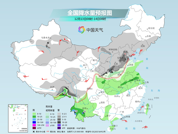
Specifically, today, there are small to medium snow or sleet in parts of central and eastern Xinjiang, most of Inner Mongolia, southern and eastern Northwest China, North China, south-central Northeast China, northern Huanghuai, eastern Tibet, and north-central Sichuan Plateau. Among them, there are heavy blizzards in parts of central Shaanxi, southwestern Shanxi, southern Hebei, southern Beijing, northern Henan and western China, among which there are heavy blizzards in parts of central Shaanxi (20 ~) There are small to moderate rains in parts of southeastern Tibet, southern and western Southwest China, south-central Huanghuai, Jianghuai, Jianghan, northern Jiangnan, eastern Hainan Island and eastern Taiwan Province Island, among which there are heavy rains (25-35 mm) in southwestern and central Yunnan and southeastern Tibet.
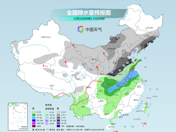
Tomorrow, there will be small to medium snow or sleet in parts of central and western Inner Mongolia, central and southern Northeast China, central and eastern Northwest China, North China, eastern Huanghuai and western China. Among them, there will be heavy snowstorms in parts of southeastern Shaanxi, northwestern Hubei, central and western Henan, southwestern Shanxi, southern Hebei, most of Shandong, eastern Liaoning and eastern Jilin, among which there will be heavy snowstorms in parts of southeastern Shaanxi, northern Henan and northwestern Shandong. There are heavy rains in parts of central and northern Anhui, central and northern Jiangsu, northern and southern Hubei, northern Hunan and northeastern Chongqing.
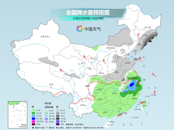
The day after tomorrow, there will be small to medium snow or sleet in parts of eastern Inner Mongolia, south-central Northeast China, southwestern Shaanxi, south-central North China, Huanghuai, western Jianghuai and eastern Hubei. Among them, there will be sleet in parts of southern Anhui and local snowstorms (10-15 mm) in eastern Jilin. There are moderate to heavy rains in parts of eastern and western Jianghuai, northern Jiangnan, central Jiangxi and eastern Jiangnan, among which there are heavy rains in parts of southern Anhui.
It is understood that the interval between the rain and snow weather in the central and eastern regions is shorter than that on December 10th, especially in North China, Huanghuai area, after the heavy snowfall on December 10th, there will be heavy snowfall again on the 13th to 14th, with a wider impact range and longer duration, and the heavy snowfall areas are highly overlapped. The daily snowfall in central Inner Mongolia, southern North China, eastern Jilin and eastern Liaoning is still extreme.
In parts of North China, Huanghuai and the south-central part of Northeast China, there is a high risk of snowstorm, low-temperature rain and snow freezing. Rain and snow weather will reduce visibility and cause snow and ice on the road, which may easily lead to traffic congestion or accidents. Snow in Jilin, Liaoning, southwestern Shaanxi, southwestern Shanxi, central and southern Hebei, northern Henan and central and northern Shandong may lead to the collapse of local simple buildings, greenhouses and livestock pens; Local freezing rain in central Shaanxi, southwestern Shanxi, central and northern Henan, Guizhou, southern Hunan and other places may cause short circuits or disconnection of power and communication facilities. The public should pay close attention to the early warning and forecasting information, and be alert to the adverse effects of snow and road icing that may be caused by rainy and snowy weather on traffic and travel, and pay attention to safety when going out.
Thick clothes warning! The cold wave will appear strongly, and the temperature in many places in the central and eastern regions will be significantly lower.
In terms of temperature, since last night, a new round of cold wave weather process has been launched strongly. This round of cold wave weather process will last until around 17th, which will bring drastic cooling to most parts of China. The Central Meteorological Observatory predicts that from 13th to 16th, northerly winds of magnitude 4 ~ 6 will appear in most parts of China, and the temperature will drop by 8 ~ 12℃, and the temperature will drop by more than 14℃ in parts of northwest China, central and western Inner Mongolia, western North China, Jiangnan, northern South China and Guizhou. There are 9 ~ 10 winds and 12 ~ 13 gusts in Shankou area of Xinjiang, and 6 ~ 8 winds and 9 ~ 10 gusts in the eastern and southern sea areas. On the morning of 17th, the lowest temperature line of 0℃ can be pressed south to southern Guizhou and northern Jiangnan, and the line of -10℃ is located from northern Huanghuai to Qinling. The lowest temperature in some areas of North China, northern Huanghuai and other places will approach or fall below the historical extreme value in the same period. The temperature in the north and south of China will hit a new low in a large area, and the temperature will generally enter a state of being significantly lower than that in the same period of last year.
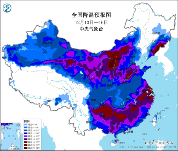
Since the last cold wave, the temperature in most parts of the north has been continuously low, and the state of low temperature and cold will continue in the coming week. Among them, the highest temperature in many places including Beijing, Tianjin, Shijiazhuang, Jinan and other big cities will fall below freezing point, and the lowest temperature will drop below -10℃ one after another. The previous cold wave process has caused the maximum temperature to have experienced a significant drop, and after this cold wave, the maximum temperature will drop to another level; The decline of the minimum temperature will be more obvious, generally from normal or high level to obviously low level, especially in the southern part of Northeast China, North China, Huanghuai and other places, the low range will reach more than 10℃, such as Taiyuan, and the minimum temperature on the morning of the 17th may be only -19℃, mainly due to a cold weather.
For the south, before the arrival of the cold wave, many places will experience a significant warming up today and tomorrow, especially in Jianghuai, Jiangnan and eastern Guizhou, where the cumulative warming range of the highest temperature is generally above 10℃, and in some areas it exceeds 15℃, and the highest temperature rises to around 25℃, which is more than 10℃ higher than normal. However, with the main cold wave heading south in the later period, all parts of the south will also experience a "big dip" in temperature. The cumulative drop of the highest temperature from Guizhou and Guangxi to Jiangnan and southern Jianghuai can reach 20℃ or above, and the highest temperature in many places will drop to about 5℃, and even approach 0℃ locally, which is obviously lower than the same period of normal years. For example, in Nanjing, the highest temperature will reach 20℃ tomorrow, and then it will drop to 1℃ on the 16th. In just a few days, the temperature will plummet, just like bungee jumping.
A new round of cold wave is coming, and the meteorological department reminds the public to pay close attention to the weather changes and prepare the thickest clothes to deal with the low temperature rain and snow.